|
The Auckland Central Archives office holds a considerable quantity of records useful for those researching the history of properties in the Auckland isthmus. The records discussed here were all created by Auckland City Council before the amalgamation that created Auckland Council in 2010. Similar material for properties on the North Shore and in West Auckland can be found in the Archives offices at Takapuna and Henderson respectively. Material for properties in South Auckland can also be made available upon request.
Rates Valuation Books 1877-1990 (Series ACC 210)
Surviving valuation books for the Auckland City Council begin in 1877. The majority of councils relied on valuations done by the central government’s Valuation Department, however, Auckland City Council was unusual in having its own Valuation Department. Information found in the valuation books includes name and occupation of owner and occupier, address of property, description and situation of rateable property, and rateable value. Rate books were based on the valuation books but included additional information on the amount of rates and payments made to council.
Rates Field Valuation Sheets 1912-2003 (Series ACC 213)
The rates field valuation sheets record the year-by-year valuations of properties in Auckland City and supplement rather than replace the rates valuation and rate books. The City Valuer and his staff created the sheets primarily as working documents for internal council use. They have a description of the property at the top, including the legal description. The names of the owner and occupier (frequently the same person) are listed in the column for the appropriate year, as is the property’s rateable value. The sheets normally list the occupier’s occupation and any improvements to the property, primarily because these affect its rateable value. Attached to the sheets may be other relevant information, for example excerpts from council or council committee minutes, newspaper clippings and small plans or sketches. Using the sheets, it is often easy to trace changes in ownership, perhaps when a spouse died and ownership passed to their survivor, or when someone inherited a property.
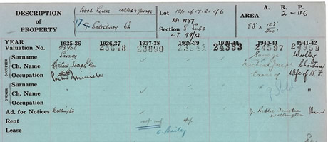 The picture shows part of the rates field valuation sheet for 17 Salisbury Street, Herne Bay, between 1935 and 1942 (Archives’ reference ACC 213/157b), owned by The Right Honourable Michael Joseph Savage (1872-1940), New Zealand’s first Labour Prime Minister. The picture shows part of the rates field valuation sheet for 17 Salisbury Street, Herne Bay, between 1935 and 1942 (Archives’ reference ACC 213/157b), owned by The Right Honourable Michael Joseph Savage (1872-1940), New Zealand’s first Labour Prime Minister.
Building Plans 1862-1993 (Series ACC 015 and AKC 339)
 Building plans kept by the City Engineer and (from 1927) the City Engineer’s Department and its successors include residential, public and commercial buildings, bridges and culverts, parks and reserves. For large buildings there may be dozens or even hundreds of plans. By-laws on building vary depending on which road or town board, borough or city council was responsible for the area on which a building stood. Building plans kept by the City Engineer and (from 1927) the City Engineer’s Department and its successors include residential, public and commercial buildings, bridges and culverts, parks and reserves. For large buildings there may be dozens or even hundreds of plans. By-laws on building vary depending on which road or town board, borough or city council was responsible for the area on which a building stood.
In Auckland City the building by-laws of 1888 required those who wished to erect, alter, add to or renew any building or structure within Auckland to give notice to Auckland City Council and submit plans and specifications to the building surveyor that were to remain in his office for twenty-four hours for inspection.
|
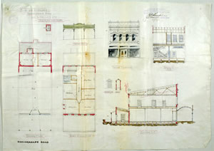
Plan of brick shop and dwelling at 506-510 Karangahape Road designed in 1912 by John Currie for G Wallace. Auckland City Council issued a building permit in 1913 and the building remains in use for shops and other businesses (Archives’ reference AKC 305/5 box 151).
|
Before work commenced, the building surveyor had to certify in writing that the specifications and plans were in accordance with the city by-laws. Since duplicate sets of plans neither were requested nor retained, Archives often lacks building plans for older buildings in the CBD or has only plans of relatively modern alterations to older buildings. New By-laws that came into force late in 1906 required those intending to erect or alter any building to submit plans and specifications to the Building Surveyor in duplicate. The surveyor was to retain one each of such duplicate plans as an office record.
By the 1920s, most building by-laws issued by local bodies in the Auckland isthmus contained a requirement that those seeking to construct new buildings or alter existing buildings should submit plans in duplicate and that one set were to be retained by the local body for record purposes.
Building Permit Cards 1908-1992 (Series ACC 431, ACC 443, ACC 428, AKC 340)
The building permit cards created by Auckland City Council and (after 1989) Auckland City are found in four separate consecutive series. They functioned as the finding aids for plans kept by the City Engineer, the City Engineer’s Department and by departments that subsequently superseded it such as the Department of Works and Services. The cards are usually arranged by street name and record the name of the property owner or contractor, permit number, date of the application, and particulars of the proposed building work. Sometimes plan numbers may also be recorded, though the plans themselves do not always survive.
To find out more about these records, go to www.aucklandcouncil.govt.nz/councilarchives or email us with your research enquiry archives@aucklandcouncil.govt.nz.
|


